About the Trail

The Larapinta Trail

The Larapinta Trail
Flora of the Larapinta Trail
The Larapinta Trail

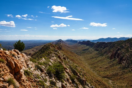
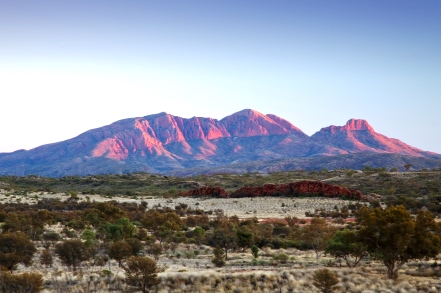
The Larapinta Trail is an extended bushwalking trail running west from Alice Springs (Telegraph Station) to Mount Sonder (Rwetyepme), along the spine of the West MacDonnell Ranges. It was completed in 2002, and its 223 kilometres are fast gaining a reputation for offering one of the finest walking experiences in the world.

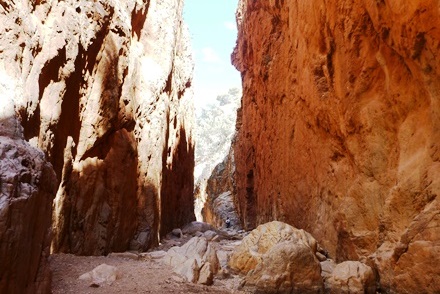
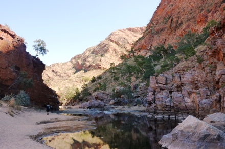
The steep red slopes of the West MacDonnell Ranges rise dramatically from the Central Australian desert. They typify the rugged landscapes of the Red Centre with the changing hues of their mountain peaks, rolling hills and dry river valleys made famous in the paintings of Albert Namatjira.

The Macdonnell Ranges are quite high by Australian standards, and the Larapinta Trail rises above 1,000 metres 7 times along its length, from a base altitude of 600m. Mt. Sonder is 1,380m high. Many sections rise from the gorges to the ridgetops and back. This is reflected in the kilometres per day recommended. Do not underestimate the trail or the time needed to complete all or any of the individual 12 sections.


Trek Larapinta provides an unequalled opportunity to experience this living desert landscape and take in its special wild and remote places. The Larapinta Trail crosses a variety of terrain, from high ridgelines to sheltered gorges and is home to many of the arid zone’s rare plants. It also links the well known visitor attractions along the ranges of the West MacDonnell National Park (Tjoritja) where walkers can join or leave the trail.

The Larapinta Trail

Traditional Custodians

Trek Larapinta wishes to acknowledge the Traditional Owners and Custodians of the Central and Western Arrernte Country for allowing us the opportunity to share this magnificent place – the Larapinta Trail and Western MacDonnell region.

We thank the traditional Arrernte owners for partnering with us to enable our guests to experience one of the most special and unique places on earth.


The Arrernte (pronounced Arunda) people of central Australia are the traditional owners of the country we walk on, sleep on, talk on and journey through. These ancient peoples have been connected to country for a very long time and belong to some of the longest continuing cultures on the planet. Some of the very first indigenous Australian dreaming stories ever recorded were those stories about beetles, caterpillars and travelling ancestral beings told by Arrernte people of Central Australia. Arrernte people continue to practice their culture in and around Alice Springs, ensuring that their language and customs are maintained.


The Map of Indigenous Australia is a useful representation of the language, social and national groups of Aboriginal Australia.

Larapinta Trail Lizard

Trek Larapinta believes that creating an understanding of the cultural past, present and future to be a crucial part of the walking journey on country. We are passionate about being part of cultural awareness and actively incorporate this in all our journeys on the Larapinta Trail.

If you would like to know more about the Arrernte people have a look at:

Araluen Arts Centre – araluenartscentre.nt.gov.au
Cultural Connections – www.culturalconnections.com.au
Alice Springs Indigenous Population – www.alicesprings.nt.gov.au/living/living-alice/aboriginal-community-culture

Highlights of the Trail and West MacDonnell Ranges

STANDLEY CHASM (ANGKERLE)
Standley Chasm cuts through tough quartzite to form a picturesque natural alleyway formed from flood waters over thousands of years. This beautiful site is at its most impressive in the middle of a sunny day when the light displays magnificent colours and forms. The reliable trickle of water in the Chasm ensures the gully floor is lush with delicate ferns to tall gum trees and cycad palms.

Standley Chasm is located in a private flora and fauna reserve owned by the Iwupataka Land Trust and is operated by Aboriginal family members that are direct descendants from Aboriginal people that have lived in this area for thousands of years.

COUNTS POINT
COUNTS POINT
At an altitude of 1,140 metres, Counts Point is one of the highest points on the Heavitree Range, From the summit the ground falls away abruptly into gracefully arched valleys reaching towards the west. The view from Counts point is arguably one of the best elevated vistas along the entire Larapinta Trail. Counts Point can be undertaken as a day walk along section 8 of the trail and is rated a hard walk.
ORMISTON GORGE (KWARTATUMA)
Ormiston Gorge showcases the spectacular geology and landforms of the West MacDonnell Ranges. The gorge has a waterhole that is there year round and is great for swimming, especially in warmer months. The popular three to four hour circuit Ormiston Pound Walk follows the rocky slope into the flat expanse of the pound and back along the gorge by the main waterhole. Sections 9 and 10 of the Larapinta Trail pass through the Ormiston Gorge area.
MT SONDER (RWETYEPME)
Mt Sonder is the fourth highest mountain in the Northern Territory at 1,380 metres. It is the final point on the Larapinta Trail at the end of Section 12. A vast 360 degree panorama greats you at the summit. Remote desert peaks stretch as far as the eye can see. The view north looks 100km into the Tanami Desert, and to the east we see the majority of the Western MacDonnell Ranges. To the south is the meteor crater of Gosse Bluff (Tnorala) and to the west Mount Zeil (Urlatherrke), the Northern Territory’s highest mountain.

LARAPINTA TRAIL GRADING

Larapinta Trail Maps

The Larapinta Trail is divided into 12 sections that each take one or two days to walk. Each section of the Larapinta Trail has been rated by level of difficulty according to the Australian Walking Track Grading System (see summary below). The Australian Walking Track Grading System is a national standard to help you work out if a walk will suit your level of fitness and experience.

As the Larapinta Trail becomes more popular the perception of its difficulty decreases. This however is not the case. The trail remains unrelentingly rocky and hard underfoot and weather extremes can be experienced at any time of the year. The more prepared you are the more you will enjoy the experience.

A Grade 3 (moderate) walk is suitable for most ages and fitness levels with some bushwalking experience recommended. Tracks may have short steep hill sections, a rough surface and many steps. Grade 4 (moderate to difficult) walks require a good level of bushwalking experience along tracks that may be long, rough and very steep. Further information about the walking track grading system can be found here.

  • Section 1 : Telegraph Station to Simpsons Gap – Grade 3 Moderate
  • Section 2 : Simpsons Gap to Jay Creek – Grade 3 Moderate
  • Section 3 : Jay Creek to Standley Chasm – Grade 4 Moderate to Difficult
  • Section 4 : Standley Chasm to Birthday Waterhole – Grade 4 Moderate to Difficult
  • Section 5 : Birthday Waterhole to Hugh Gorge – Grade 4 Moderate to Difficult
  • Section 6 : Hugh Gorge to Ellery Creek – Grade 3 Moderate

  • Section 7 : Ellery Creek to Serpentine Gorge – Grade 4 Moderate to Difficult
  • Section 8 : Serpentine Gorge to Serpentine Chalet Dam – Grade 4 Moderate to Difficult
  • Section 9 : Serpentine Chalet Dam to Ormiston Gorge – Grade 4 Moderate to Difficult
  • Section 10 : Ormiston Gorge to Finke River – Grade 3 Moderate
  • Section 11 : Finke River to Redbank Gorge – Grade 4 Moderate to Difficult
  • Section 12 : Redbank Gorge to Mt Sonder return – Grade 4 Moderate to Difficult

Trek Larapinta supplies basic trail maps as part of their fully-supported Larapinta Trail tours. Detailed Larapinta Trail maps can also be purchased.

Other Information

Due to large bushfires caused by mismanagement of campfires by walkers and non-walkers, there is a total fire ban on the Larapinta Trail. Please adhere to the total fire ban, as this will help with regeneration of affected areas, provide a good balance of natural habitat and promote the future well-being of the Park.

Trek Larapinta camps in areas where fires are permitted by permit, and our firewood is sourced from outside the park. We also work at keeping our use of firewood to a minimum.

Water is generally available at most trailheads, where water tanks are installed and maintained by National Parks. Parks recommend that all water, including tank water, be treated before use. Please check with NT Parks and Wildlife for up-to date information on water and other trail facilities

Mobile phone reception is very limited along the trail, so a working emergency communication option is highly recommended (satellite phone or personal locator beacon).

Larapinta Trail Weather

Our Larapinta Trail Tours operate from April to September inclusive.

The climate in the cooler months is near-perfect for walking. Below are the average weather conditions for Alice Springs. Temperatures are in degrees Celsius.

  • Month
    • January
    • February
    • March
    • April
    • May
    • June
    • July
    • August
    • September
    • October
    • November
    • December

  • Average Max Temp
    • 36
    • 35
    • 32
    • 28
    • 23
    • 20
    • 20
    • 22
    • 27
    • 31
    • 33
    • 35

  • Average Min Temp
    • 21
    • 21
    • 17
    • 12
    • 8
    • 5
    • 4
    • 6
    • 10
    • 15
    • 18
    • 20

  • Rainy Days
    • 5
    • 4
    • 4
    • 2
    • 3
    • 3
    • 3
    • 2
    • 2
    • 5
    • 6
    • 6

Accredited Tourism Business Australia